
| MN State Facts |
|---|

|
| Territory: Mar 3, 1849 |
| Statehood: May 11, 1858 |
| Counties: 87 |
| Borders: IA, MI, ND, SD, WI and Can |

| MN Resources |
|---|
| MN Land Ownership Maps |
| MN Maps & Atlases |
| MN Birth, Marriage & Deaths |
| MN Military Databases |
| MN Record Collections |
| MN Historical Newspapers |
| Create a Free Family Tree |
Maps of Minnesota are a great resource to help learn about a place at a particular point in time. Old Minnesota maps are effective sources of geographical information and useful for historical, genealogical and territorial research.
Our collection of Minnesota maps includes many different historic and modern types of maps. The maps date from the 19th century to the present and include:

- Minnesota Township maps, including maps showing the progress of the original government surveys
- Minnesota Road, Highway and railroad maps
- Minnesota Maps showing the state’s geological features
- Minnesota timeline of county boundaries changes
- Minnesota Military maps
- Minnesota Maps of specific towns, counties and bodies of water
- Territorial era maps of Minnesota
- Bird’s eye views of Minnesota cities and towns
Historical Maps of Minnesota are a great resource to help learn about a place at a particular point in time. Minnesota Maps are vital historical evidence but must be interpreted cautiously and carefully.
The map collection of the Minnesota Historical Society consists of over 35,000 individual Minnesota maps and 1,300 atlases, the majority of these for Minnesota and the Midwest. The society is a five-state regional depository for the U.S. Geological Survey maps. It has extensive collections of Minnesota territory and state maps, county and city maps, and fire insurance maps of over 950 Minnesota towns and cities.
There are random maps and plat maps in the county records at the Minnesota Historical Society Research Center. The map library of the Wilson Library at the University of Minnesota, Minneapolis, is an outstanding cartographic repository, not restricted to Minnesota. It includes worldwide maps and associated material.
County atlases for Minnesota include maps for the respective county and for townships within that county. The names of property owners are frequently included on these maps. The Minnesota Historical Society has microfilmed many of these atlases, which makes them accessible on inter-library loan.
Library of Congress Fire Insurance Maps in the Library of Congress; Plans of North American Cities and Towns Produced by the Sanborn Map Company states that the earliest map of this type for Minnesota is for 1884. There is, however, a Sanborn map for the city of St. Paul for 1875; this map is located at the map library of the Minnesota Historical Society.
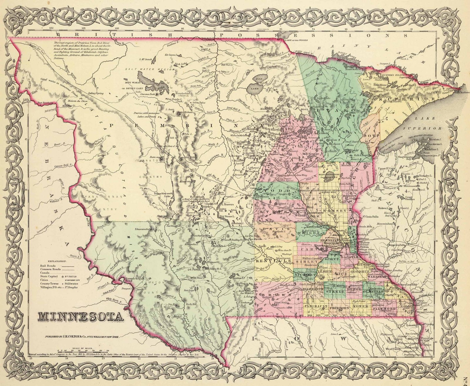
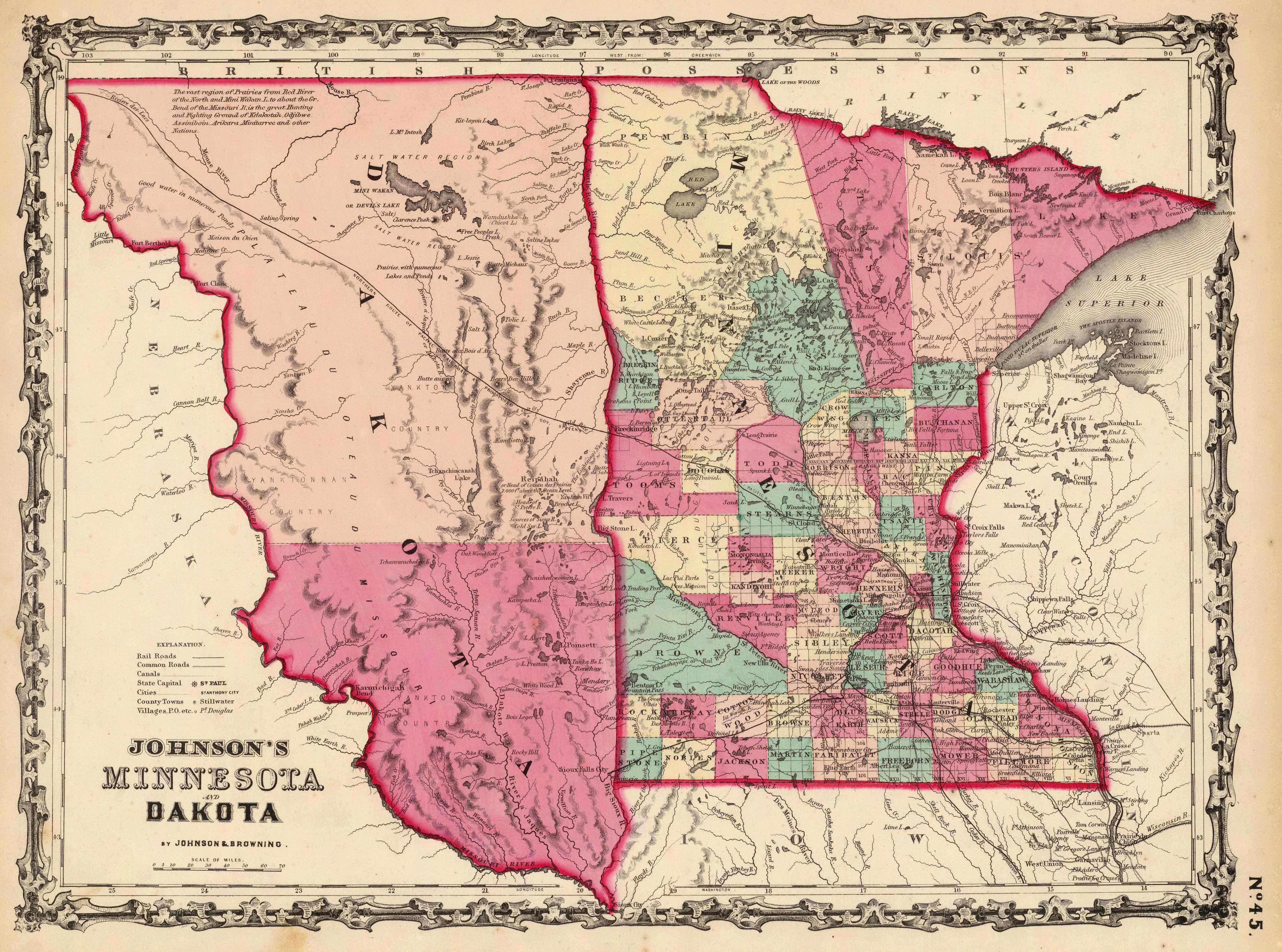
Old Historical Atlas Maps of Minnesota
This Historical Minnesota Map Collection are from original copies. Most historical maps of Minnesota were published in atlases and spans over 150 years of growth for the state.
Some Minnesota maps years have cities, railroads, P.O. locations, township outlines, and other features useful to the Minnesota researcher.


Map of Minnesota County Formations 1801-1937
This Interactive Map of Minnesota Counties show the historical boundaries, names, organization, and attachments of every county, extinct county and unsuccessful county proposal from the creation of the Minnesota territory in 1801 to 1937.
Minnesota County Maps of Road and Highway’s
The Minnesota D.O.T. Highway Department has prepared a series of 2015 county road maps for free online. These maps contain more detailed information about man-made features than the geological survey maps.
In addition to roads and boundaries, these maps include rural communities, churches, and cemeteries. These Minnesota maps are Free to downloade are in PDF format.
External Minnesota Map Resources
- Old Historical Maps of Minnesota (alabamamaps.ua.edu)
- Minnesota Maps, Atlases & Gazetteers (ancestry.com)
- U.S., Indexed County Land Ownership Maps, 1860-1918 (ancestry.com)
- Library of Congress Minnesota Map Collections (loc.gov)
- Old Maps of Minnesota (old-maps.com)
- Minnesota Antique Maps and Historical Atlases (historicmapworks.com)
- Historical Minnesota State Maps (mapsofthepast.com)
- Antique Maps of Minnesota (raremaps.com)
- Minnesota Map Books (amazon.com)