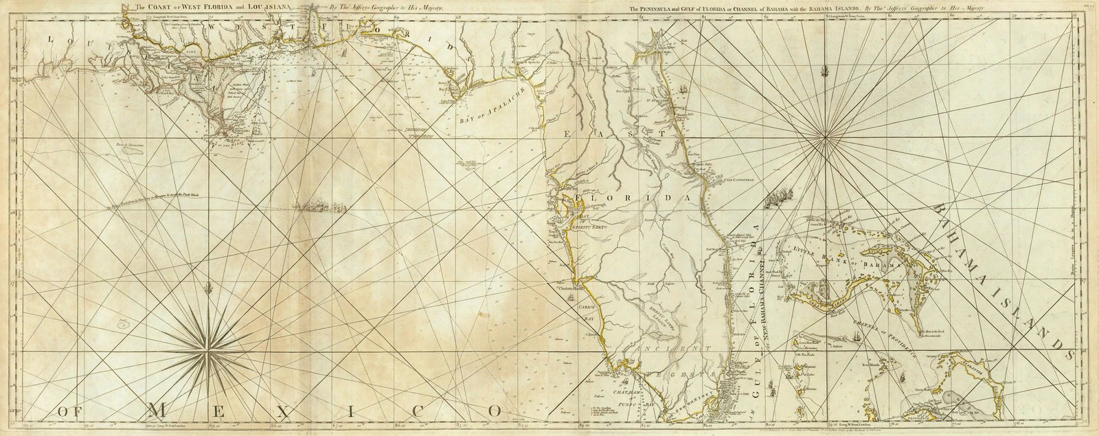
Maps of Louisiana are a great resource to help learn about a place at a particular point in time. Old Louisiana maps are effective sources of geographical information and useful for historical, genealogical and territorial research.

Our collection of Louisiana maps includes many different historic and modern types of maps. The maps date from the 18th century to the present and include:

State Map of Louisiana Parish Boundaries and Parish Seats
  • Save
State Map of Louisiana Parish Boundaries and Parish Seats
  • Louisiana Township maps, including maps showing the progress of the original government surveys
  • Louisiana Road, Highway and railroad maps
  • Louisiana Maps showing the state’s geological features
  • Louisiana Nautical charts
  • Louisiana timeline of parish boundaries changes
  • Louisiana Military maps
  • Louisiana Maps of specific towns, parishes, islands, harbors, and bodies of water
  • Colonial era maps of Louisiana
  • Bird’s eye views of Louisiana cities and towns

There are large Louisiana map collections in both university libraries and public libraries. There are also several map collections in historical and genealogical societies, as well as private collections and archives.

The French Quarter is home to the Historic New Orleans Collection, which includes the d’Auberville-Bouligny Family Papers and the Bouligny Family Papers. Those collections include maps and large amounts of documentation about the Spanish and French colonial times.

There is information found in Louisiana maps that cannot be found elsewhere. For example, the Claude Perrin Victor Papers and the Pierre Clement de Laussat Papers are particularly full of useful information.

Antebellum era maps can also give researchers insights into transportation methods and population growth across Louisiana.

Every piece of property in the French Quarter is listed in the Vieux Carr Survey. Photographs, drawings, and property title chains are included. The Historic New Orleans Collection also includes many of those documents.

Original survey plats, field notes, and maps of Louisiana that were made by early surveyors working for the United States can be found in Baton Rouge at the State Land Office, which is in the State Land and Natural Resources Building. The clerk of courts office in each parish courthouse may also hold plat maps, which list land ownership.

Old Historical Atlas Maps of Louisiana

This Historical Louisiana Map Collection are from original copies. Most historical maps of Louisiana were published in atlases and spans over 225 years of growth for the state.

Some Louisiana maps years have cities, railroads, P.O. locations, township outlines, and other features useful to the Louisiana researcher.

1752 State Map of Louisiana
  • Save

d’Anville’s 1752 Carte de la Louisiane (State Map of Louisiana)

  • Map Date: Dessiné en Mai 1732 (Publiee en 1752)
  • Map Locations: Louisiana, Alabama, Mississippi
  • Map Publication:
  • Map Type: Survey Map
  • Map Cartographer: Jean Baptiste Bourguignon d’Anville (1697-1782)
1776 Map of the Coast of West Florida and Louisiana with the Bahama Islands
  • Save

Jeffery’s 1776 Map of the Coast of West Florida and Louisiana with the Bahama Islands

  • Map Date: 1732
  • Map Locations: Florida and Louisiana
  • Map Publication: The American Atlas: Or, A Geographical Description Of The Whole Continent Of America
  • Map Type: World Atlas
  • Map Cartographer: Samuel Holland and Thomas Jefferys
1776 Map of the Course of the Mississipi River from the Balise to Fort Chartres
  • Save

Jeffery’s 1776 Map of the Course of the Mississippi River from the Balise to Fort Chartres

1804 State Map of Louisiana
  • Save

Arrowsmith’s 1804 State Map of Louisiana

  • Map Date: 1804
  • Map Locations: Louisiana
  • Map Publication: A new and elegant general atlas, comprising all the new discoveries, to the present time.
  • Map Cartographer: Aaron Arrowsmith (1750-1823) and Samuel Lewis (1754-1822)
1814 State Map of Louisiana
  • Save

Carey’s 1814 State Map of Louisiana

  • Map Date: 1814
  • Map Locations: Louisiana
  • Map Publication: Carey’s General Atlas, Improved And Enlarged; Being A Collection Of Maps Of The World And Quarters, Their Principal Empires, Kingdoms, &c
  • Map Type: World Atlas
  • Map Cartographer: Henry Charles Carey and Isaac Lea
1822 Geographical, Historical and Statistical State Map of Louisiana
  • Save

Carey’s 1822 Geographical, Historical and Statistical State Map of Louisiana

  • Map Date: 1822
  • Map Locations: Louisiana
  • Map Publication: A Complete Historical, Chronological, And Geographical American Atlas, Being A Guide To The History Of North And South America, And The West Indies … To The Year 1822.
  • Map Type: National Atlas
  • Map Cartographer: Henry Charles Carey & Isaac Lea
1827 Map of Alabama, Louisiana and Mississippi
  • Save

Finley’s 1827 State Map of Louisiana, Alabama and Mississippi

  • Map Date: 1827
  • Map Locations: Alabama, Louisiana and Mississippi
  • Map Publication: A New General Atlas, Comprising a Complete Set of Maps, representing the Grand Divisions of the Globe, Together with the several Empires, Kingdoms and States in the World; Compiled from the Best Authorities, and corrected by the Most Recent Discoveries, Philadelphia, 1827.
  • Map Type: National Atlas
  • Map Cartographer: Anthony Finley (1784 – 1836)

Tanner’s 1836 State Map of Louisiana with Its Canals, Roads & Distances from place to place, along the Stage & Steam Boat Routes with New Orleans.

  • Map Date: 1836 (Entered 1833)
  • Map Locations: Louisiana, New Orleans
  • Map Publication: A New Universal Atlas Containing Maps of the various Empires, Kingdoms, States and Republics Of The World.
  • Map Type: World Atlas
  • Map Cartographer: Henry Schenck Tanner (1786–1858)
1845 State Map of Louisiana
  • Save

Morse’s 1845 State Map of Louisiana

  • Map Date: 1842 (Entered 1842)
  • Map Locations: Louisiana
  • Map Publication: Morse’s North American atlas. Containing the following beautifully colored maps
  • Map Type: National Atlas
  • Map Cartographer: Sidney Edwards Morse (1794-1871 ) and Samuel Breese (1802-1873)
1856 State Map of Louisiana
  • Save

Colton’s 1856 State Map of Louisiana

  • Map Date: 1856 (Entered 1855)
  • Map Locations: Louisiana
  • Map Publication: Colton’s Atlas Of The World, Illustrating Physical And Political Geography.
  • Map Type: World Atlas
  • Map Cartographer: Joseph Hutchins Colton (1800-1893)
1856 City Map of New Orleans LA with City of Louisville KY
  • Save

Colton’s 1856 City Map of New Orleans LA with City of Louisville KY

  • Map Date: 1856 (Entered 1855)
  • Map Locations: Cities of New Orleans, LA and Louisville, KY
  • Map Publication: Colton’s Atlas Of The World, Illustrating Physical And Political Geography.
  • Map Type: World Atlas
  • Map Cartographer: Joseph Hutchins Colton (1800-1893)
1866 State Map of Louisiana Public Survey Sketches by the Department of Interior Land Office
  • Save

1866 State Map of Louisiana Public Survey Sketches by the Department of Interior Land Office

  • Map Date: October 2nd 1866
  • Map Locations: Louisiana
  • Map Publication: Maps accompanying Report of the commissioner of the General Land Office.
  • Map Type: National Atlas
  • Map Cartographer: United States. General Land Office.
1880 State and County Map of Louisiana, Arkansas and Mississippi
  • Save

Mitchell’s 1880 State and County Map of Louisiana, Arkansas and Mississippi

  • Map Date: 1880 (Entered 1879)
  • Map Locations: Arkansas, Mississippi and Louisiana
  • Map Type: World Atlas
  • Map Cartographer: Samuel Augustus Mitchell Jr. (1827-1901)
1880 City Map of New Orleans
  • Save

Mitchell’s 1880 City Map of New Orleans

  • Map Date: 1880 (Entered 1879)
  • Map Locations: City of New Orleans, Louisiana
  • Map Type: World Atlas
  • Map Cartographer: Samuel Augustus Mitchell Jr. (1827-1901)

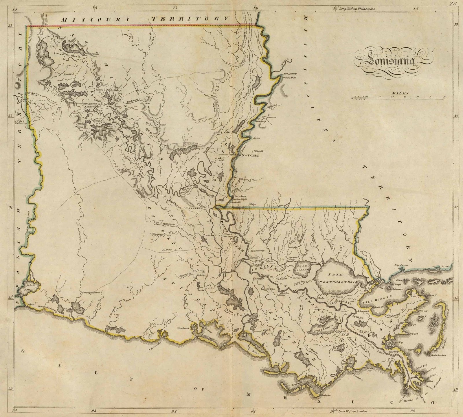
Map of Louisiana Parish Formations 1805-1990

This Interactive Map of Louisiana Parishes show the historical boundaries, names, organization, and attachments of every parish, extinct parish and unsuccessful parish proposal from the creation of the Louisiana territory in 1805 to 1990.

Louisiana Parish Maps of Road and Highway’s

The Louisiana D.O.T. Highway Department has prepared a series of 2016 parish road maps free onlinr. These maps contain more detailed information about man-made features than the geological survey maps.

In addition to roads and boundaries, these maps include rural communities, churches, and cemeteries. These Louisiana maps are Free to downloade are in PDF format.

External Louisiana Map Resources

Scroll to Top
0 Shares
Share via
Copy link