
| Map Geeks |
|---|

|

| US Resources |
|---|
| US Land Ownership Maps |
| US Maps & Atlases |
| U.S. Gazetteer, 1854 |
| AL Military Databases |
| AL Record Collections |
| AL Historical Newspapers |
| Create a Free Family Tree |
| Map & Atlases |
|---|
| Types of Maps |
| Types of Atlas Maps |
| Types of Family Tree Maps |
| World Map Collections |
| Maps of the U.S. |
| Maps of Europe |
| Maps of North America |
| Maps of South America |
| Maps of Asia |
| Maps of Middle East |
Maps are an excellent source to help you investigate your family tree. In addition to more modern different types of maps , a number of older types of maps may be useful in researching your family tree depending upon your specific research needs and goals.
Confused about where exactly your ancestors were born? Map out your ancestors’ big life events using these different types of historic maps such as City Ward, City Directory, Fire Insurance, Plat, Province, County, and Parish Maps and more.
Being familiar with the area in which an ancestor lived is essential to family history research. By using vintage maps, you can learn more about the name, location, and history of the city or town in which your ancestors lived.
This information is a valuable starting point for your research leading you to the right location of records.
Historical atlas maps can indicate who owned specific property in the state and which towns held the county seat at the time. This, in turn, can help you uncover new record sources for your ancestors.
Solving Research Problems with Maps
If you have started your family research, you might have experienced trouble with trying to identify city borders and names that have changed over the course of time.
This can make it difficult to understand where your ancestors’ information is kept. Because historical maps were usually commissioned by the county seat, they often display information about the county, including town names. Reading a map from the time period you are researching can help tremendously in solving these problems by leading you to the correct town records.
It can also give you other leads, such as the location of city directories or old post offices.
Choosing the Best Map
If you have a large source of maps to choose from, try starting with the area where your ancestors resided and looking for the maps with the most detail. You can determine a lot by seeing if the area was still rural or more developed, and how far it was to the nearest city.
This can shed light on your family’s lifestyle and occupation. Were they farmers who lived in the country, or merchants who traveled often to a nearby city? A map can give you an idea of what occupations were possible.
Researching Beyond Maps
Once you have some basic details from your map research, you can use it to search through other historical sources. You can often find details about births, deaths, and marriages at the local library.
By reading obituaries or news articles
US Maps are a Great Starting Point
The most overwhelming aspect of researching family history is deciding where to start. However, getting started is the key. Each piece of history that you uncover offers new leads as your family’s story takes shape.
State Maps are an excellent resource to start your journey. The basic information about borders and towns can save you time by directing you to the correct records to begin your investigation.
The work gets easier and more interesting as you follow each lead and learn more about the background of your own story. The value of preserving your family history for future generations is immeasurable.
Surveys, Plat Maps, and Land Maps

What are Surveys, Plat Maps, and Land Maps?
Family history researchers can often find exciting information in old ownership maps and plat maps. Those maps indicate landowners in a certain place at a certain time in history.
The government generally maintains property and land records carefully, since those records indicate changes in ownership of a given piece of land. So, those records can provide vital historical and ancestral information.
Plat books and land maps generally list a property’s owner, as well as surrounding neighbors and other useful items. They can be obtained from town halls, county courthouses, historical societies, and other repositories.
In general, most land ownership maps were done on a county level, but that wasn’t true in every case. Most of those maps will at least give the names of land owners.
They may also state the number of acres owned, the crops harvested on the land, and whether the land was farmland or forest. The amount of dwellings and buildings and their types may also be listed, along with other important structures in the area, such as churches, courthouses, and major roads.
The researcher can use plat map information, such as townships, ranges, and sections, to locate tax and deed records about their ancestors. It’s also noteworthy that ethnic groups tended to settle in the same area.
So, looking at maps may yield other relatives or neighbors who shared the same town of origin in their home countries. Researchers may find those cross-connections useful tools for filling in the branches of the family tree.
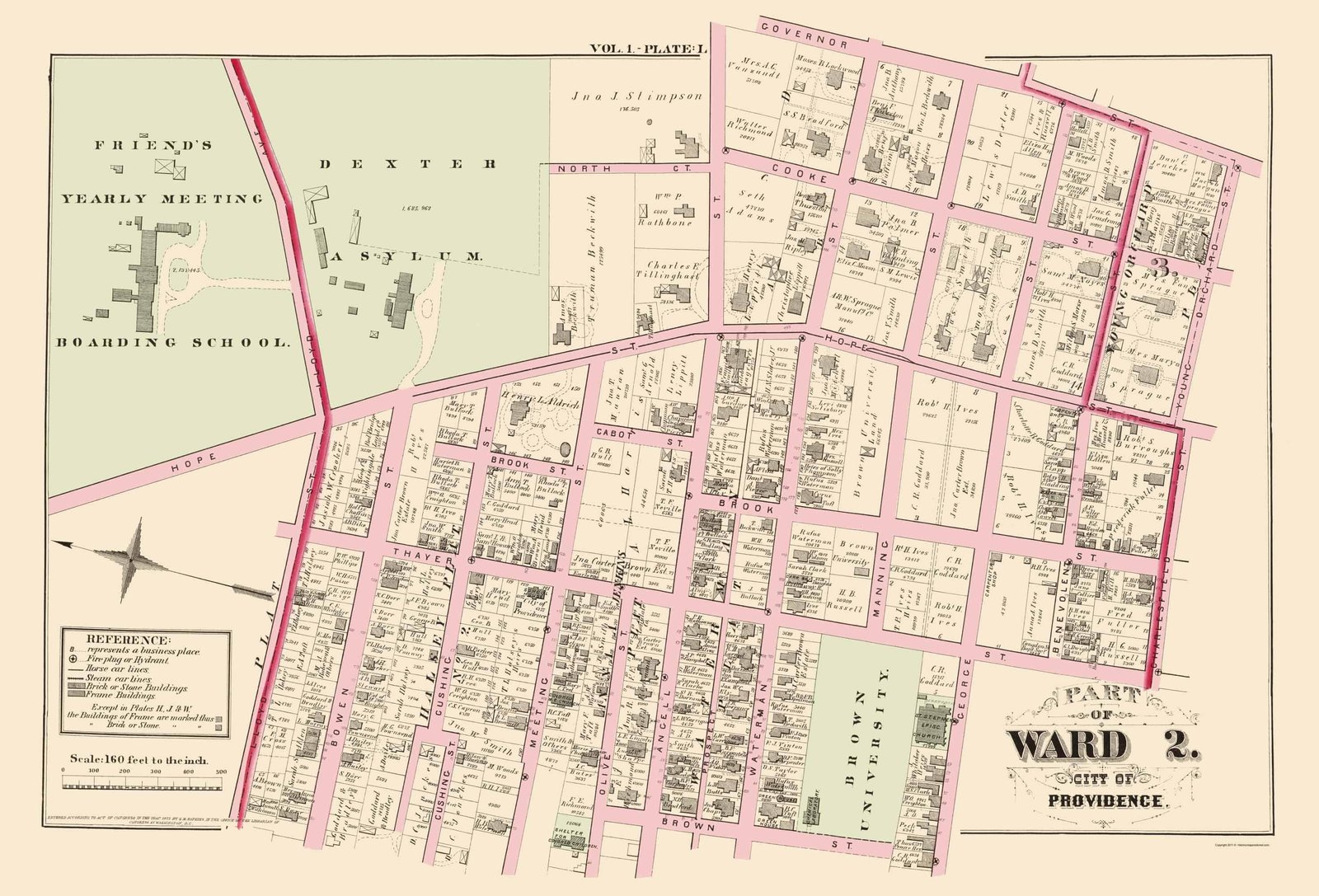
Ward Maps

What is a Ward Map?
Ward maps can be helpful to researchers who are trying to locate census records for years that were not indexed that relate to large cities.
A ward map generally shows boundaries of each ward in a given city in a given year. For example, let’s say that the researcher is trying to find an ancestor who lived in 1870 in Indianapolis, Indiana.
The researcher should start by looking at the city’s 1870 directory and recording the ancestor’s street address. Then the researcher can locate that address on the 1870 Indianapolis ward map.
It is much faster to scan the page headers of an unindexed census for information and then apply that information when researching a ward map, as opposed to searching the entire city for the ancestor in question. This research method also helps when an ancestor is not listed in a census index, but it is believed that they lived in that particular city at that particular time.
Often, city directories include ward maps in the back or front as supplemental pages. Public libraries often have their own town or city’s directories on file. They may also have directories for surrounding cities and towns.
Larger collections of directories can also be found in state libraries, often on microfilm. Cartographic collections in certain institutions may also include ward maps.
Province, County, and Parish Maps
What are Province, County, and Parish Maps?
Researchers may not find all of the information that they need in simple road maps and atlases. So, the next step is to explore local maps from a given time period.
They often show such details as cemeteries, major landmarks, county roads, and other important features. Those sort of maps can be found in government and county offices, generally.
Each of those organizations may have records, and those records could include information about the ancestor in question. Fire insurance maps can also indicate how an area grew and changed.
Fire Insurance Map
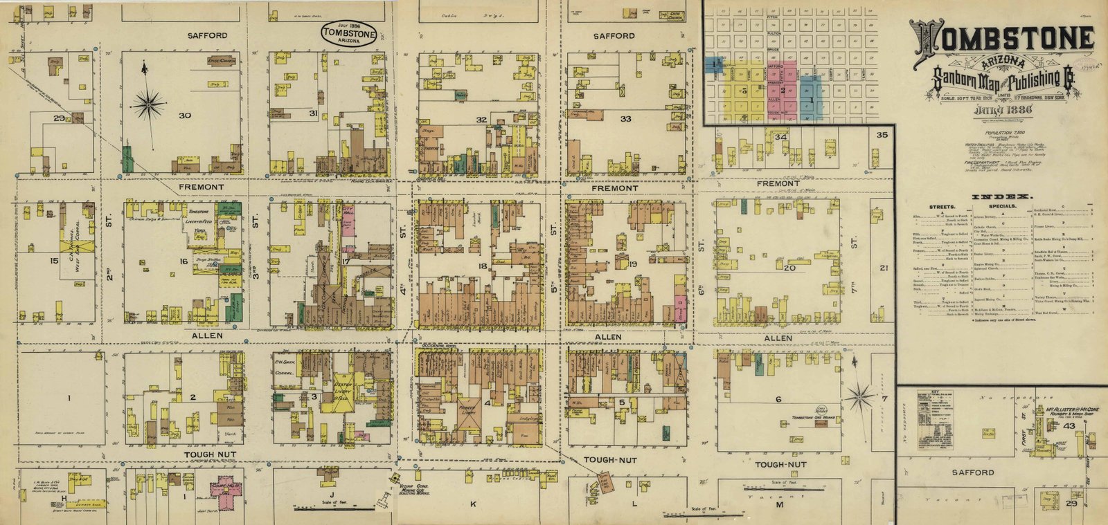
What are Fire Insurance Maps?
Fire insurance maps can provide unusual and interesting information for researchers.
For example, in cases where dwellings are re-numbered, a fire insurance map may be able to help the researcher pinpoint the old dwelling in question.
Such maps can also be used to determine which institutions in the area an ancestor may have visited and spent time in. Some possible institutions to consider are: schools, churches, grocery stores, department stores, lumber yards, and laundry facilities.
Each of those organizations may have records, and those records could include information about the ancestor in question. Fire insurance maps can also indicate how an area grew and changed.
City Directory Maps

What is a City Directory Map?
Genealogists tend to use city directories to fill in information that would ordinarily be found in census records that are missing.
However, many of those directories also include maps, which can show the topography of the region, including rivers, roads, and railroads.
Also, roads and streets that are no longer in existence today or have changed names can often be identified by comparing city directory maps.